
Skate Skiing on Crust around Jackson Hole.

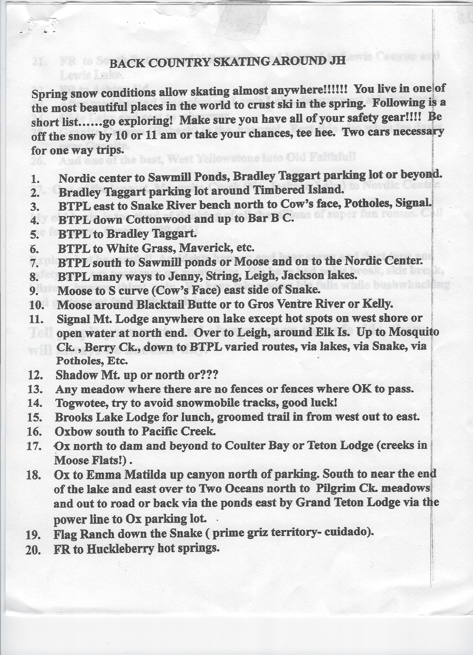
Ski the list posted on the front of the Wadsworth’s fridge
“You don’t have to be far from town to need help… and you are still responsible for having an extra layer and a way to call for help.”
Matt Hansen, avid Cache Creek Nordic Skier and the communications director for the TCSAR Foundation
Gwenn and Don Wadsworth have been skiing here since the late 70’s, as in 1970’s! And they still get after it every winter. That’s a lot of skiing. You can learn more about them in this story, but as March storms transition to April crust, we asked if we could steal the page off of their refridgarator to inspire our readers to find new places, or maybe the same places but with new joy, to glide over the crust on skate skis.
The JH Nordic Alliance team has skied many of these. Mapped trail description pages are linked in the modified list below. A few relevant notes have been added to the original list. Exploring can be half the fun so some routes are left as they existed on the fridge page! Wherever you cruise on your skate skis, please check for permission to be wherever you want to go, and know whether having your dog with you is okay. Responsible recreation is up to all of us, all of the time.
- Nordic Center to Sawmill Ponds, Bradley Taggart parking lot (BTPL) or beyond
- Bradley Taggart paring lot around Timbered Island
- BTPL east to Snake River beach north, to Cow’s Face, Potholes, Signal
- BTPL down to Cottonwood and up to B Bar C
- BTPL to Bradley Taggart Lakes
- BTPL to White Grass, Maverick, etc
- BTPL south to Sawmill Ponds or Moose and on to the Nordic Center
- BTPL many ways to Jenny, String, Leigh and Jackson Lakes
- Moose to S Curve (Cow’s Face), east side of Snake
- Moose Around Blacktail Butte or to Gros Ventres River or Kelly
- Signal Mountain Lodge to anywhere on lake except hot spots on west shore or open water at north end. Over to Leigh, around Elk Island. Up to Mosquito Creek, Berry Creek. Down to BTPL varied routes via lakes, via Snake, via Potholes, etc.
- Shadow Mountain, up it, near it, north of it, around it…
- Any meadow where there are no fences or fences that are ok to pass over or through.
- Togwotee, try to avoid snowmachine tracks
- Brooks Lake Lodge for lunch, some of which may be groomed
- Oxbow south to Pacific Creek
- Oxbow north to dam and beyond to Coulter Bay or Teton Lodge (watch for open creeks in Moose flats)
- 18. Oxbow to Emma Matilda, on to Two Oceans, north to Pilgrim Creek and out.
- Flagg Ranch down the Snake (prime grizzily territory – cuidado)
- Flagg Ranch to Huckleberry hot springs area.
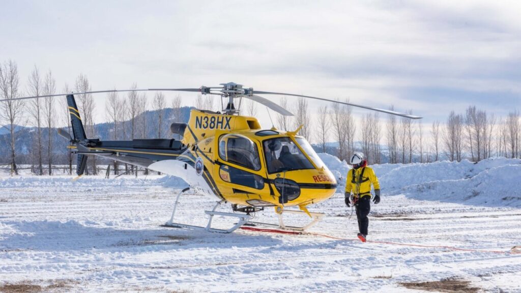
Rescues are not just for gravity sports! TCSAR and TCISAR are available in and around the Tetons to provide emergency support if you are out on a groomed track in the winter and unable to return to the trailhead or parking lot under your own power. To reach SAR, it’s a good idea to Know Before You Go, think about your options and maybe load an app on your phone. Although fewer than one Nordic skier per year might need a SAR response, it sure is amazing that we have such talented and dedicated experts when we do need them. In “Tougher Than a Spud Bar” Matt Hansen shares an unusual incident on a close to home trail. My eyes got wider as I listened to the challenges that came out of a very ordinary ski on a section of track I have traversed dozens of times.

Where to Listen to Tougher Than a Spud Bar
Spotify Apple Podcasts Sound Cloud
With a renewed respect for cattle guards, here are a few tips on what it mean to Know Before You from the folks who do this for a living, the Teton County Search and Rescue (TCSAR).
What to know before you go for a ski
- Have a plan before you go—and stick to it.
- Tell someone where you are going, and approximately when you will be back.
- In the event you change your plans on the fly, connect with them again, before you go out of service.
- Carry food, water and an extra warm layer.
- Bring a charged cell phone and have it within reach. To conserve battery, you can put it in low power mode and keep it in a warm place/inner pocket.
Cody Lockhart, TCSO Chief Advisor, shares a few tips on connecting to search and rescue as well as a very quick primer on BackcountrySOS and Garmin inReach at the beginning of this 10 minute clip.
How to connect to SAR in an emergency
Connect with your trail partner first
Whether it’s with a shout to get their attention, or by phone if you are out on a groomed track together but in different places, your first priority is to call your ski partner. Another skier or trail user is a good next step – asking for help early is a little extra insurance you may be happy to have had in the event you don’t need as much help as you thought.
Engage BackcountySOS
BackcountrySOS is a free app developed by TCSAR Foundation that acts as a text to 911 with minimal cell service. These notifications go directly to dispatch. The app is available in 12 counties across the Intermountain West and provides first responders with your exact location and nature of your emergency. It does not allow two-way communication. Download the Backcountry SOS from your app store, now, as you are reading this, to have it ready on your phone.
Dial or Text 911
911 calls in Teton County go to local dispatch, who then contacts the TCSAR Board of Advisors to formulate a rescue plan. In Teton County WY we also have text to 911. If cell phone reception is too weak to place a call try texting.
Use a handheld satellite device
Handheld satellite devices, such as SPOT or Garmin inReach, have SOS capabilities that allow the user to connect with the International Emergency Response Coordination Center (IERCC), which can then connect to local dispatch. An inReach allows two-way text communication.
Apple Watch
Apple Watch has a new feature called Fall Detection that allows the user to turn on an alarm that detects a hard fall with a prompt to call for help. If the user is immobile for one minute the device will call for help and notify the emergency contacts set up on the phone. This has caused false alarms for active users, so be sure to use your discernment.
iPhone Satellite Feature
With an iPhone 14 or later, you can send iMessages or SMS messages via satellite when you’re off the grid with no cellular and Wi-Fi coverage. You will need a clear view of the sky and the horizon, so connections could be limited in the mountains. However, as of the fall of 2024, Apple was not recommending this new feature for emergency situations. Instead, Apple recommends texting emergency services using the EmergencySOS via satellite.
What should you say when you call 911?
- Provide your location first in case the call gets dropped.
- Provide the nature of the accident and condition of the person in need.
- Try not to move around when speaking so that the call does not drop.
- Unless you are in immediate danger, stay in your same location until Search & Rescue arrives.
Additional resources to help you be prepared, practiced and present.
Curious about what you might want to bring in addition to your warm layer and phone on your next Nordic adventure? Check out “What’s in Your Pack” to see what long-time skiers and Teton locals Don and Gwenn Wadsworth bring in their packs when they cross-country ski.
For more education about being ready for all kinds of adventure, check out Backcountry Zero, the education and community outreach arm of Teton County Search & Rescue Foundation. Backcountry Zero aims to empower our community with the skills, knowledge and resources we need to prevent incidents and fatalities in the backcountry. They host a couple dozen workshops and sessions each winter to support our community being prepared, practiced and present in the backcountry (which is maybe closer to home than you think it is!).
Happy to not need search and rescue in Teton Canyon on a quiet early season blue sky day.